Isle Of Sheppey Round the Island Race
Sailboat passing Kingsferry Bridge
Home
Entry Form
Notice of Race
Sailing Instructions
Course Map
Results
Past Winners
Photos
Video Clips
Press Cuttings
How to get here
Accomodation

Event organised by
IOS Sailing Club

Enquiries:


Course map and hazards


The course starts and finishes at IOS Sailing Club and
is sailed in a clockwise direction around the island.

Download a more detailed course map (PDF)


1. Cheyney Rock (Map)
A large 'L' shaped area of sand stones and rocks that dries several feet high at low water, but cannot be seen at other times. The bank is situated just to the east of IOSSC, between the CYC Coastal Club building and a large cardinal post which is visible at all times.
2. Minster Boom Defense
A wartime submarine trap of sunken barges and posts in a long line marked by a cardinal buoy.
3. Shallow water area, risk of grounding (Map)
Large sand bank from Leysdown to Shell Ness.
4. Horse Sands (Map)
Sand bank before Harty Ferry in the Swale.
5. Fowley Island (Map)
Marshland bank, keep north to the Island side.
6. Elmley (Map)
North Ferry and South Ferry buoys where tide changes and buoys change direction. An old causeway either side of the main channel still exists at low water.
7.

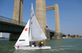
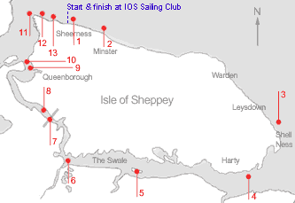
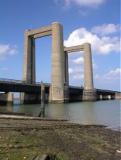
The Kingsferry Bridge (Map)
The Kingsferry Bridge is the bridge which links the island to mainland - the middle section of the bridge lifts but only for ships.

All competitors will be permitted to negotiate the bridge by sailing, wading, or paddling. No special arrangements will be made for multihulls. There may be marshals in the immediate vicinity of the bridge who can be called upon to give assistance.

Competitors are advised to walk their craft under the mainland side of the bridge. Watch out for ships coming through the lifting section of the bridge to and from Ridham docks. Sailing through the centre span is not permitted, unless agreed in advance with OOD due to nature of craft entered (ie. fixed keel).

8. Long Reach Ski Club (Map)
Ski club area: expect speed boats, jet and water skiers.
9. Queenborough Hard (Map)
Long submerged concrete hard at Queenborough.
10. Queenborough Dolphins
Marks of old pier remain.
11. Garrison Point and Ferry Berth (Map)
The Swale, Medway and Thames Estuary tides meet at this point, giving rise to a back eddy and tidal ring (disturbed water) approx. 100 feet deep. Watch out for shipping.

Please be aware of a new (2021) mooring line which may extend from the end of the jetty at Garisson Point to a large yellow mooring buoy for a new ferry, which should not be crossed - please pass to the north of the large yellow mooring buoy.
12. Outfall Buoy (Map)
This disused outfall pipe poses considerable danger to small craft, as the posts supporting this pipe cannot be seen at most states of the tide. A yellow cardinal buoy, close to Garrison Point marks end of the pipe and posts - you're best keeping to the north of this.
13. Swimming Zone
Marked by small plastic yellow buoys.
 

Photos © J. Bell

Share: